Outer Banks, North Carolina, August 25, 2025
News Summary
Hurricane Erin left a trail of destruction along the East Coast, including significant flooding in the Outer Banks, North Carolina. With ocean overwash inundating homes and vital access roads, emergency officials remain on high alert. Rescue efforts were initiated in Margate City, New Jersey, where over 50 individuals were saved from trapped vehicles. Coastal flooding has curtailed transportation and raised safety concerns for locals and tourists alike as high rip current risks persist.
Outer Banks, North Carolina – Hurricane Erin Causes Significant Flooding and Damage Along East Coast
On August 24, 2025, significant flooding and extensive damage resulted from Hurricane Erin as it moved away from the East Coast. Although the hurricane had weakened to a Category 1 before its departure on August 22, the storm left a path of flooded roads, sand-covered beaches, and dangerous surf conditions for beachgoers in several states.
Emergency declarations were issued in advance of the storm, with New Jersey declaring a state of emergency on August 21 to prepare for anticipated flood impacts and high winds. In Margate City, New Jersey, rescue efforts led to the successful extraction of over 50 individuals, including three dogs, trapped in flooded vehicles and restaurants. The Margate City Fire Department tackled multiple emergencies arising from the flooding, including incidents involving gas leaks and electrical fires.
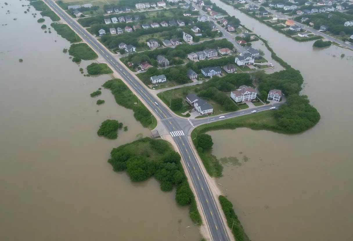
Flooding and Erosion in North Carolina
In North Carolina’s Outer Banks, ocean overwash inundated homes and hotels prior to the issuance of storm surge warnings. High water levels at Duck Beach recorded 6.97 inches during high tide on August 21, dangerously close to the 2003 record set during Hurricane Isabel. Due to these conditions, parts of roads along the Outer Banks, particularly between Oregon Inlet and Ocracoke, are expected to remain impassable, especially during high tide periods. Transportation crews have been actively working to reinforce dunes to protect the critical Highway 12, which is the main access road into the area.
As of August 22, numerous breaches in the dunes along Highway 12 compelled temporary road closures. However, no significant pavement damage has been reported. Additionally, coastal flooding in New Jersey forced the closure of U.S. 40 in both directions in Pleasantville, with lane closures impacting traffic in North Wildwood and Ocean City. In Delaware, beach erosion occurred near Indian River Inlet due to water overtopping the dunes.
Increased Risks and Ongoing Monitoring
In the aftermath of Hurricane Erin, high rip current risks remain at East Coast beaches despite the storm’s departure. Beach closures were mandated on August 22 in several states, including North Carolina and New Jersey. The National Weather Service emphasizes the dangers of rip currents, which have been responsible for 10-15% of fatalities from tropical storms and hurricanes in the past decade.
Forecasters continue to monitor three developing systems in the Atlantic, one of which has an 80% chance of becoming the next named storm, dubbed Fernand. Hurricane Erin was classified as a Category 4 hurricane at its peak, boasting sustained winds of 130 mph. Remarkably, the storm reached Category 5 status with near 160 mph winds before weakening within a mere 24 hours. As one of the fastest-strengthening storms on record, Erin has joined an elite group of 43 Category 5 hurricanes ever recorded in the Atlantic, including eleven since 2016.
Impact and Continuing Concerns
The current Atlantic hurricane season has exhibited above-average tropical activity, further underscoring the importance of staying informed. August is recognized as the busiest period for hurricane activity, particularly from mid-August to mid-October. The 2025 hurricane season is projected to see this trend continue. Erin’s outer bands also brought heavy rainfall to Puerto Rico, where over 100,000 residents have been left without power as of August 24, with the potential for additional rainfall raising concerns of flash flooding and landslides.
Conclusion
The devastation caused by Hurricane Erin is a stark reminder of the power of nature, leading to urgent responses and preparations along the East Coast. As recovery efforts continue, residents and visitors are urged to remain cautious and adhere to safety updates.
FAQ
What were the peak wind speeds of Hurricane Erin?
Hurricane Erin reached peak wind speeds of nearly 160 mph, classified as a Category 5 hurricane at that time.
How many people were rescued in Margate City, New Jersey?
Emergency responders rescued over 50 individuals, including three dogs, from flooded vehicles and restaurants in Margate City, New Jersey.
What are the ongoing weather concerns following Hurricane Erin?
High rip current risks remain at East Coast beaches, and forecasters are monitoring several developing systems in the Atlantic.
What measures were taken in North Carolina to protect against flooding?
Transportation crews worked to reinforce dunes along Highway 12 to protect the critical access road into the Outer Banks.
| Feature | Data |
|---|---|
| Hurricane Classification | Category 1 (formerly Category 5) |
| Peak Winds | 160 mph |
| Rescues in Margate City | Over 50 individuals, including 3 dogs |
| Emergency Declarations | New Jersey declared a state of emergency |
| Inundation Levels at Duck Beach | 6.97 inches |
| Power Outages in Puerto Rico | Over 100,000 residents affected |
Deeper Dive: News & Info About This Topic
HERE Resources
Hatteras Island Evacuation Orders Lifted After Hurricane Erin
Hurricane Erin Threatens Outer Banks with Evacuations
Hurricane Erin Causes Severe Damage in Rodanthe
N.C. Highway 12 Reopens Following Hurricane Erin
Precautionary Swimming Advisory Issued for Outer Banks
N.C. Highway 12 on Hatteras Island Safe for Travel After Hurricane Erin
Hurricane Erin Causes Severe Coastal Flooding Along East Coast
Hurricane Erin Triggers Evacuations in Outer Banks
N.C. Highway 12 Closed Due to Hurricane Erin Impact
Beach Homes in Rodanthe Threatened by Hurricane Erin
Additional Resources
- Fox Weather: NC-12 Travel Impacts Erin
- USA Today: Hurricane Erin Flooding
- CBS News: Hurricane Erin Lashes Outer Banks
- Wikipedia: Hurricane Erin (2025)
- NBC News: Hurricane Erin Brings Violent Waves
- Google Search: Hurricane Erin
- Wavy: Impact of Hurricane Erin
- Encyclopedia Britannica: Hurricane Erin
- WRAL: Beaches Reopen After Hurricane Erin
- Google News: Hurricane Erin


