Nags Head, NC, September 15, 2025
News Summary
The National Weather Service has issued a coastal flood advisory for the Northern Outer Banks and Hatteras Island as Hurricane Erin, a strong Category 2 storm, approaches. Residents are warned of rising water levels and hazardous conditions, with potential storm surges and high surf expected. Evacuations are mandatory for Ocracoke and Hatteras Islands, and residents should take precautions to ensure safety during the storm.
Nags Head, NC – Coastal Flood Advisory Issued for Northern Outer Banks and Hatteras Island as Hurricane Erin Approaches
The National Weather Service (NWS) Newport/Morehead City NC has issued a coastal flood advisory, effective until Tuesday at 8 p.m., for the Northern Outer Banks and Hatteras Island due to the impending effects of Hurricane Erin. Residents in low-lying areas can expect water levels to rise by 1 to 2 feet above ground level, posing immediate risks of flooding in vulnerable communities.
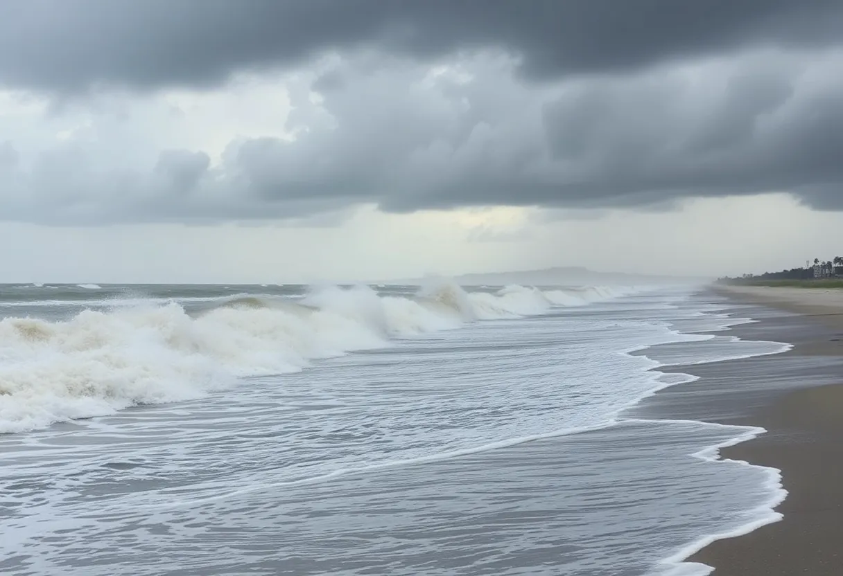
As Hurricane Erin approaches as a strong Category 2 storm with winds reaching 110 mph, the National Hurricane Center anticipates life-threatening impacts along the North Carolina coastline. Coastal flooding and beach erosion are exacerbated by expected storm surges of 2 to 4 feet and waves potentially reaching up to 20 feet. Isolated road closures are likely due to flooding, leading to hazardous conditions for both drivers and swimmers.
Travelers are advised to factor in possible road closures while planning their routes, especially around areas known for heavy flooding. Residents and campers in flood-prone zones are urged to seek higher ground and follow evacuation orders promptly. In addition, homeowners should take precautionary measures by locking their homes and disconnecting utilities before evacuating.
Safety Warnings and Recommendations
With strong rip currents expected, especially around low tide at 8 a.m. on Monday, swimming and surfing conditions will be perilous. Rip currents are particularly dangerous, potentially pulling even the most skilled swimmers into deeper waters. Isolated incidents of neck and back injuries may occur due to treacherous shore breaks, and strong longshore currents will further heighten swimming hazards.
Reports of hydroplaning due to wet roads are anticipated, underscoring the need for caution when driving during the storm. Even just 6 inches of moving water can knock individuals off their feet, prompting emergency services to advise against any unnecessary travel. If caught in moving water, individuals should try to reach high ground and contact emergency services for assistance.
In addition to flood risks, mandatory evacuation orders are now in effect for Ocracoke and Hatteras Islands. Governor Josh Stein has declared a state of emergency to streamline resource allocation in anticipation of the storm’s impact. Many areas may experience severe flooding and heavy rain, threatening homes and businesses with structural damage.
Local Responses and Resources
The North Carolina Department of Transportation (NCDOT) has announced that NC Highway 12 will remain closed in specific areas due to ongoing cleanup from Hurricane Erin. All Dare County offices and facilities will resume normal operations on Monday after their temporary closure due to the hurricane. However, advisories for swimming and surfing remain in effect, particularly focusing on high surf conditions along the beaches.
Health advisories have also been issued in several areas, including Buxton, due to potential water quality concerns stemming from water main breaks and flooding. A boil water advisory is currently in place for affected regions. Local emergency services stand ready to assist communities, with potential shelter openings available for displaced residents affected by the storm.
As the area prepares for the ramifications of Hurricane Erin, residents are reminded to avoid water activities and to stay informed of rapidly changing coastal conditions. It is critical to heed all warnings and advisories during this time, ensuring safety and preparedness.
Conclusion
The coastal flood advisory serves as a stark reminder of the vulnerabilities along the North Carolina coast as Hurricane Erin approaches. Individuals should take precautions and remain vigilant to ensure their safety and that of their communities.
Frequently Asked Questions (FAQ)
What areas are under a coastal flood advisory?
The coastal flood advisory affects the Northern Outer Banks and Hatteras Island.
What are the expected impacts of Hurricane Erin?
Expected impacts include coastal flooding, high surf conditions, and wind gusts up to 110 mph, along with significant risks for structural damages and travel hazards.
What safety measures should residents take before the storm?
Residents should secure their homes by locking doors, disconnecting utilities, seeking higher ground if in low-lying areas, and following evacuation orders if issued.
Key Features of the Advisory
| Feature | Details |
|---|---|
| Flood Advisory Duration | Until Tuesday at 8 p.m. |
| Expected Inundation | 1 to 2 feet in low-lying areas |
| Wave Height | Up to 20 feet |
| Wind Speed | Up to 110 mph |
| Evacuation Orders | Mandatory for Ocracoke and Hatteras Islands |
| Health Advisories | Boil water advisories in affected regions |
Deeper Dive: News & Info About This Topic
HERE Resources
Virginia Reports Record Tourist Spending in 2024
North Carolina Faces Hurricane Vulnerability Amid FEMA Criticism
Carolina Beach Faces Increasing Flood Risks Due to Supermoon Tides
Homeowners in Rodanthe Face Erosion Challenges
Hurricane Erin Causes Devastating Flooding in Outer Banks
North Carolina’s Outer Banks Prepare for Hurricane Erin
Hurricane Erin’s Impact on Sea Turtle Nests in North Carolina
Coastal Erosion Threatens Homes on North Carolina’s Outer Banks
Outer Banks Faces High Rip Current Risk as Hurricane Erin Approaches
Ocracoke, North Carolina Faces Aftermath of Hurricane Erin
Additional Resources
- Charlotte Observer: Hurricane Erin Update
- Wikipedia: Hurricanes in the United States
- CBS 17: Hurricane Erin Threat
- Google Search: Hurricane Erin North Carolina
- ABC11: Hurricane Erin Live Updates
- Encyclopedia Britannica: Hurricane
- Fox Weather: Hurricane Erin Coastal Damage
- Google News: Hurricane Erin


