Nags Head, North Carolina, September 8, 2025
News Summary
Hurricane Erin, a Category 3 storm with winds reaching 110 mph, is moving towards North Carolina’s Outer Banks, leading to mandatory evacuations for Hatteras and Ocracoke Islands. Coastal flooding is expected, raising concerns for further impacts on local infrastructure and businesses. Residents are recommended to secure properties and stay away from the ocean due to hazardous rip currents. Experts link this hurricane’s intensity to climate change, highlighting ongoing concerns for coastal communities.
Nags Head, North Carolina – Hurricane Erin Prompts Evacuations and Coastal Flooding Warnings
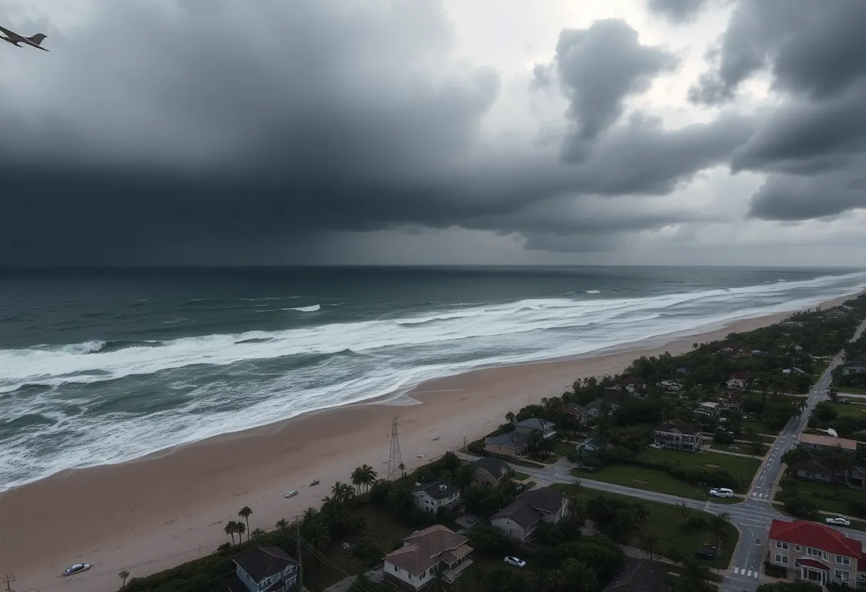
Hurricane Erin, now a Category 3 hurricane with maximum sustained winds of 110 mph (175 kph), is approaching North Carolina’s Outer Banks, prompting concerns over dangerous rip currents and waves that could reach 15 feet (4.6 meters). In anticipation of the storm’s potential hazards, evacuation orders have been issued for barrier islands, including Hatteras and Ocracoke islands.
Authorities have warned residents and visitors of the dangers posed by rip currents and have issued tropical storm warnings and surge watches across much of the Outer Banks. As of the latest updates, Hurricane Erin remains situated approximately 665 miles (1,070 kilometers) southwest of Bermuda and is moving northwest at 7 mph (11 kph).
Local business owners, including Holly Andrzejewski, have begun preparations by rescheduling guests and reinforcing properties against the impending storm. Outdoor furnishings are being secured, and essential supplies such as generators, water, and flashlights are being stocked to ensure safety.
Impact and Response
Based on current forecasts, coastal flooding is anticipated to commence Tuesday and extend through Thursday, creating risks for road and infrastructure damage. A local state of emergency is in effect for Hatteras Island due to expected flooding and potential road impassability. The last evacuation for Ocracoke occurred during Hurricane Dorian in 2019.
Recent reports from Wrightsville Beach indicate that at least 60 swimmers were rescued due to perilous conditions caused by rip currents. The situation worsened with multiple rescues reported in New Hanover County, revealing the dangerous environment created by the hurricane’s effects.
Scientific Context
Experts have linked rapid hurricane intensification to climate change, noting a correlation between rising ocean temperatures and the strength of storms. Hurricane Erin briefly reached Category 5 status before settling back to Category 3, a reflection of the ongoing changes in the storm’s structure. As it approaches Bermuda, the area could face severe weather conditions, with wave heights potentially reaching 24 feet (7 meters).
Coastal communities are particularly warned about the risk of significant beach erosion and flooding coinciding with high tides. With historical weather data showing that the Outer Banks has a history of being severely impacted by storms, precautions are being taken to minimize the potential for damage.
Safety Measures
Residents are strongly urged to remain out of the ocean due to the life-threatening conditions imposed by rip currents and the high surf. Officials continue to emphasize the seriousness of the situation, emphasizing that even experienced swimmers would face extreme dangers under current conditions.
The N.C. Department of Transportation has highlighted that maintenance and repairs for N.C. Highway 12, which frequently suffer damage from storms, cost the state over $1 million annually. As Erin approaches, the department remains vigilant regarding the potential impacts on transportation infrastructure.
Preparedness Efforts
As Hurricane Erin remains in motion, those living in or visiting the Outer Banks are reminded to prepare adequately and stay informed about ongoing developments. The collaboration between local authorities, businesses, and residents plays a crucial role in ensuring safety as they face the approaching storm.
FAQ
What is Hurricane Erin’s current status?
Hurricane Erin is a Category 3 hurricane with maximum sustained winds of 110 mph, posing risks of coastal flooding and dangerous surf conditions along North Carolina’s Outer Banks.
What areas are under evacuation orders?
Mandatory evacuations have been ordered for Hatteras and Ocracoke islands due to expected storm impacts.
What precautions should residents take?
Residents are advised to secure their properties, stock up on essential supplies, and avoid ocean activities due to the life-threatening rip currents and high waves.
What are the expected weather conditions?
Coastal flooding is expected to begin on Tuesday and last through Thursday, with wave heights potentially reaching up to 15 feet and severe conditions anticipated in surrounding areas.
How does Hurricane Erin compare to past storms?
This evacuation for Ocracoke is the first since Hurricane Dorian in 2019, signaling serious concerns among local residents and authorities about the storm’s potential impact.
Key Hurricane Erin Impact Features
| Feature | Description |
|---|---|
| Category | Category 3 Hurricane |
| Wind Speed | 110 mph (175 kph) |
| Wave Heights | Up to 15 feet (4.6 meters) |
| Evacuations | Mandatory for Hatteras and Ocracoke islands |
| Flooding Risk | Coastal flooding expected from Tuesday to Thursday |
| Impact History | Ocracoke’s first evacuation since 2019 hurricane season |
Deeper Dive: News & Info About This Topic
HERE Resources
Newport, North Carolina Faces Life-Threatening Rip Currents
Hurricane Erin Approaches Outer Banks, NC: Tropical Storm Watch in Effect
North Carolina’s Outer Banks Devastated by Hurricane Erin
Discover North Carolina’s Charming Small Towns for Travelers
Tragic Drowning Incident in Nags Head, North Carolina
Fishing Trip Turns Troublesome for Captain Danchise
Hurricane Erin Triggers Life-Threatening Coastal Conditions in North Carolina
Motorist Delays on N.C. Highway 12 Due to Waterline Project
Hurricane Erin Triggers High-Risk Conditions Along North Carolina’s Outer Banks
Hurricane Erin Triggers Evacuations in Hatteras, NC
Additional Resources
- Ocracoke Observer
- AP News
- Washington Post
- CNN
- CBS News
- Wikipedia: Hurricane Erin
- Google Search: Hurricane Erin
- Google Scholar: Hurricane Erin
- Encyclopedia Britannica: Hurricane Erin
- Google News: Hurricane Erin


