North Carolina, August 20, 2025
News Summary
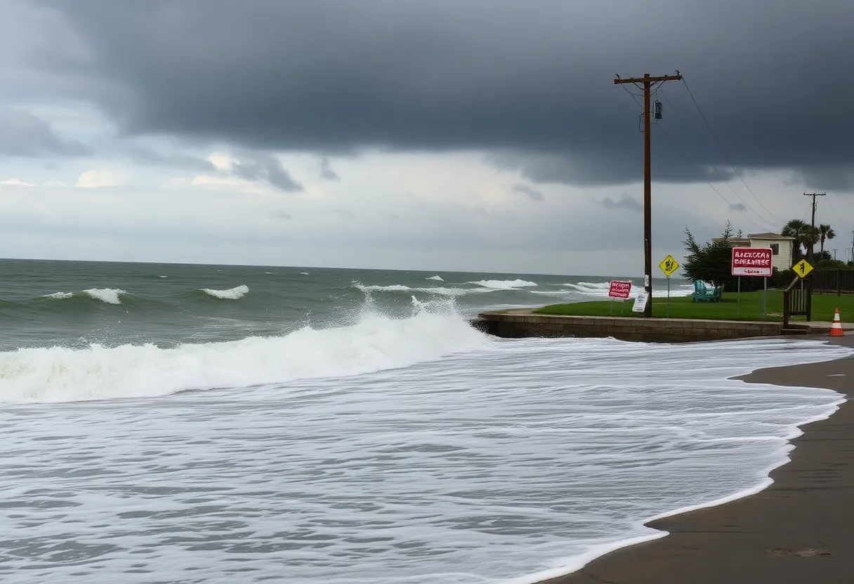
Hurricane Erin is significantly impacting the East Coast, particularly North Carolina, where mandatory evacuations are in effect for Hatteras and Ocracoke Islands. Although currently a Category 2 storm with winds of 110 mph, Erin has resulted in dangerous rip currents and swells of up to 20 feet. Authorities have mobilized emergency management officials, urging residents and tourists to follow evacuation orders as coastal flooding and storm surges loom. Given its rapid intensification attributed to climate change, Hurricane Erin poses serious challenges for local communities and economies.
North Carolina
Hurricane Erin is currently impacting the East Coast with hazardous conditions, including dangerous rip currents and mandatory evacuation orders in effect for parts of North Carolina. The storm, which has not made landfall but is tracking northward just offshore, has resulted in swells reaching up to 20 feet along the state’s barrier islands. Although Erin initially intensified to a Category 5 hurricane over the weekend, it has since weakened to a Category 2 as of Tuesday morning.
As of Tuesday, Hurricane Erin was situated approximately 665 miles southwest of Bermuda and 720 miles south-southeast of Cape Hatteras. Despite not being on track to make landfall, meteorologists at the National Hurricane Center (NHC) expect the storm to expand, increasing the risk of severe rip currents in the days to come. Mandatory evacuations have been ordered for the Hatteras and Ocracoke Islands, where NC Highway 12, the sole route for access, faces potential damage from coastal flooding.
Authorities reported around 70 rescues due to rip currents on North Carolina beaches, particularly at Wrightsville Beach. As a result, tourists have been urged to stay out of the water during this hazardous period. Swimming has been banned at New Jersey and New York beaches due to unsafe conditions caused by the storm. A Tropical Storm Warning remains in effect from Beaufort Inlet to Duck, along with a Tropical Storm Watch extending from Cape Charles Light in Virginia to Chincoteague. Furthermore, a Storm Surge Warning is active for the Outer Banks region.
Emergency management officials have been mobilized in response to the potential impacts of Hurricane Erin, with Hyde County declaring a state of emergency for Ocracoke Island and additional evacuations underway. Residents and tourists in the Outer Banks, home to approximately 3,500 residents and tens of thousands of tourists, are particularly vulnerable as the storm threatens to create life-threatening conditions, with storm surges expected to reach up to 4 feet and total rainfall of 1 to 2 inches anticipated.
The rapid intensification of Hurricane Erin, ranking among the fastest-growing hurricanes in recorded history, poses significant risks attributed to the ongoing impacts of climate change. At its peak, the storm recorded sustained winds of 110 mph while moving northwest at 7 mph. Category 2 hurricanes, classified by sustained winds of 96 to 110 mph, can bring severe destruction, edging close to the threshold of Category 3 status.
Local economies, particularly in Dare County, contribute around $2 billion annually from tourism. The cycle of rebuilding after hurricanes is a familiar process, as past storms have created new inlets and caused extensive damage, leading to lengthy recovery periods. With rising sea levels and increasing coastal erosion, the threats posed by hurricanes such as Erin are becoming more pronounced for communities along the Outer Banks.
Emergency Preparedness and Response
Municipal authorities are encouraging residents to stay informed and follow all evacuation orders and safety guidelines. These measures are crucial to ensure the safety of residents and tourists in the region as Hurricane Erin continues to churn offshore.
Storm Key Features
- Storm Name: Hurricane Erin
- Category: 2 (previously Category 5)
- Sustained Winds: 110 mph
- Location: 665 miles southwest of Bermuda, 720 miles southeast of Cape Hatteras
- Expected Impact: Dangerous rip currents, coastal flooding, storm surges up to 4 feet
- Evacuations: Hatteras and Ocracoke Islands
- Emergency Declarations: Hyde County
FAQ
What is the current status of Hurricane Erin?
Hurricane Erin is a Category 2 storm located off the coast of North Carolina, producing dangerous surf conditions and rip currents.
Where is Hurricane Erin located?
As of Tuesday morning, it is approximately 665 miles southwest of Bermuda and 720 miles south-southeast of Cape Hatteras, North Carolina.
Are evacuation orders in place?
Yes, mandatory evacuation orders have been issued for Hatteras and Ocracoke Islands due to the risk of coastal flooding.
What should tourists do?
Tourists are encouraged to avoid entering the water due to hazardous conditions and to follow any local advisories and evacuation orders.
What impact has Hurricane Erin had already?
High surf and rip currents have already resulted in numerous water rescues along the North Carolina coastline, and emergency services are on high alert.
Key Features of Hurricane Erin
| Feature | Details |
|---|---|
| Storm Name | Hurricane Erin |
| Current Category | Category 2 |
| Previous Peak Category | Category 5 |
| Sustained Winds | 110 mph |
| Location | 665 miles southwest of Bermuda; 720 miles southeast of Cape Hatteras |
| Evacuations | Mandatory for Hatteras and Ocracoke Islands |
Deeper Dive: News & Info About This Topic
HERE Resources
Hurricane Erin Approaches North Carolina’s Outer Banks
Hurricane Erin Hits North Carolina as a Category 2 Storm
Maryland Beaches Closed Due to Hurricane Erin’s Threats
Hurricane Erin Approaches North Carolina’s Outer Banks
Hurricane Erin Forces Evacuations in Outer Banks
Hurricane Erin Forces Evacuations in Outer Banks, NC
Outer Banks, North Carolina Braces for Hurricane Erin
Hurricane Erin Triggers Evacuations and Warnings Along U.S. East Coast
Hurricane Erin Strengthens as It Approaches Outer Banks, NC
Hurricane Erin Forces Evacuations in Hatteras, NC
Additional Resources
- ABC News: Hurricane Erin
- NBC News: Hurricane Erin Expected to Grow
- Fox Weather: Hurricane Erin Impacts
- The New York Times: Hurricane Erin Evacuations
- CBS News: North Carolina Evacuations
- Wikipedia: Hurricane
- Google Search: Hurricane Erin
- Google Scholar: Hurricane Erin
- Encyclopedia Britannica: Hurricane Erin
- Google News: Hurricane Erin


