News Summary
Tropical Depression Chantal brought heavy rainfall to eastern Triad communities, particularly Alamance County, leading to significant flooding as the Haw River approached record levels. The storm also caused tornado activity and damage in several counties. Residents remain cautious as more rain is expected throughout the week.
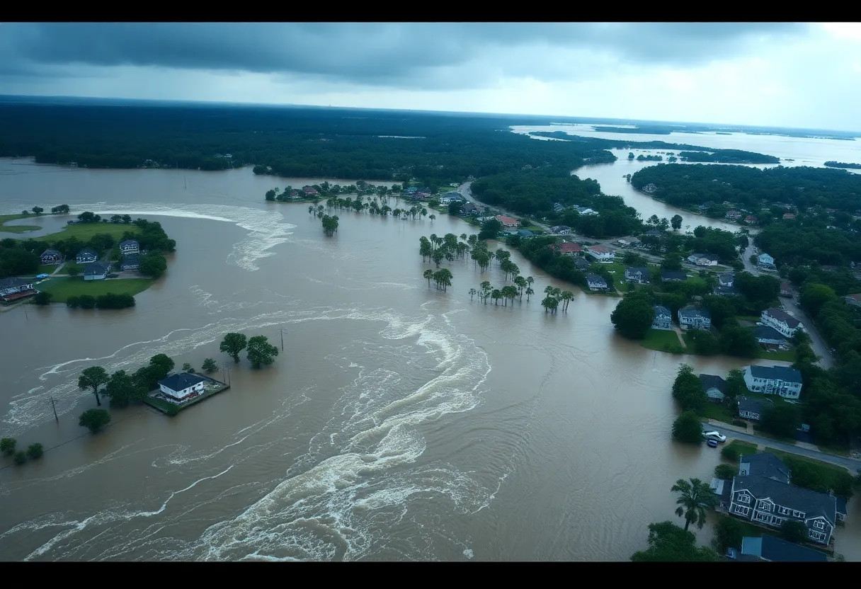
Burlington, North Carolina – Tropical Depression Chantal unleashed heavy rains this past weekend, leading to significant flooding in parts of eastern Triad communities, particularly in Alamance County, where the Haw River approached record flooding levels. The storm made landfall in South Carolina on July 4 and brought severe weather as it tracked through North Carolina, impacting Central North Carolina Piedmont counties with both flooding and tornado activity.
On Sunday night, the Haw River reached a major flood stage of just below 32 feet, nearing its all-time record high crest of 32.8 feet. Residents faced rising waters as rainfall totals in Alamance, Randolph, and Caswell counties ranged from 2 to 6 inches, with additional rains of 1 to 3 inches forecasted for the following days. The river’s crest surpassed flooding levels from Hurricane Florence, which peaked at 26.3 feet in September 2018.
The National Weather Service reported that at the 28-foot mark, floodwaters overtopped the bridge at I-40. The Haw River is anticipated to remain at major flood stage until late Monday afternoon. Flash flooding, exacerbated by tropical storm rainbands, was reported across the eastern Triad through Sunday night, impacting numerous neighborhoods.
As Chantal progressed, residents remained vigilant amid reports of tornado activity. The National Weather Service confirmed at least two tornado touchdowns: one in Lee County at the Raleigh Executive Jetport and another near Moncure in Chatham County. Damage occurred in the form of downed trees near Pittsboro, alongside structural damage to hangars and aircraft in Lee County. A separate investigation was underway regarding a possible tornado touchdown near Mebane.
As the week continues, spotty storms are anticipated in the region, with isolated tornadoes still a possibility throughout eastern Triad communities. Despite the severe weather, temperatures in the Outer Banks climbed into the upper 80s on Tuesday, providing stark relief from the preceding rain.
Coastal cities from Myrtle Beach to Surf City are expected to feel brief impacts from the storm’s remnants, with significant wave heights of 8 to 10 feet observed from Oak Island to Myrtle Beach. Beachgoers have been advised to stay alert for potential coastal weather impacts, though no trip cancellations have been issued. Rain chances are forecasted to be higher along the coast compared to Central North Carolina.
Tropical Depression Chantal originated from an area of low pressure near Florida and the Georgia coast. Initially forming on July 4, it briefly intensified over warm Gulf Stream waters before making landfall. The storm’s effects are expected to linger, leading to ongoing opportunities for showers and storms throughout the remainder of the week.
The threat of flooding and severe weather continues to necessitate caution in affected areas, as the conditions remain unstable due to Chantal’s influence. Communities are advised to monitor local weather reports and stay prepared for possible changes in weather patterns.
Deeper Dive: News & Info About This Topic
HERE Resources
High Rip Current Warning Issued for North Carolina Beaches
Tropical Storm Chantal Hits South Carolina
Tropical Storm Chantal Strikes North Carolina
Tropical Storm Chantal Hits South Carolina Coast
Tropical Storm Chantal Hits the Southeast U.S. Coast
Tropical Depression 3 Forms Off South Carolina Coast
Tropical Storm Watch Issued for North and South Carolina Coastlines
Tropical Depression Three Forms Off The Southeast Coast
North Carolina Launches Hurricane Preparedness Campaign
High Winds and Coastal Flooding Expected in the Outer Banks
Additional Resources
- WXII12: Tropical Chantal Landfall in North Carolina
- Google Search: Tropical Chantal
- Weather.com: Nags Head, NC 10-Day Forecast
- Wikipedia: Flood
- ABC11: NC Weather – Storms and Heat
- Encyclopedia Britannica: Tornado
- WTKR: First Warning Forecast – Tropical Storm Chantal
- Google News: North Carolina Weather
- WTKR: Outer Banks Forecast
- WRAL: Historic Snow in Outer Banks


